Suggested changes to the Beach Measurement Program Statement of Work

Shown below is a 2012 aerial view of a Corolla oceanfront home taken from the County’s GIS application.   Below it is a side elevation view cross-section sketch.  Labels on the diagrams indicate the key parameters necessary to understand the risks of future property value degradation/ loss due to storms. 

Screen Shot 2019-03-10 at 3.03.08 PM.png

Exhibit: Key Metrics Needed to Project Future Impact of Beach Erosion on County Tax Base


For this property the toe of the dune is about 5 ft above sea level and the peak of the dune about 16 feet above sea level.  Despite sand fencing, beach grass planting and bringing in 20-30 truckloads of sand since 2012 the peak of the dune has moved about 6 feet closer than noted in the figure above to the house and pool..

For County management the key questions that need to be answered are as follows:

What is the width of the useable dry sand beach and how is this width changing?

If average beach erosion continues how many years before the swimming pool and house foundation will be undermined?  What is the tax impact when this occurs?

After what period of average beach erosion will the pool or house infrastructure be subject to undermining by a single hurricane event like Isabel?

When and where must the County begin beach nourishment to prevent the possibility of significant tax value loss due to an Isabel scale event?


Suggested changes to the County’s statement of work


Lidar measurements – The contractor should indicate the following:

 with reference to the leading eastern faceof each oceanfront home:

·     Distance to the peak of the dune

·     Elevation of the peak of the dune

·     Distance from peak of dune to toe of dune

·     Elevation of the toe of the dune

·     Width of the useable dry sand beach

·     Distance to high water mark ( roughly 2 ft above mean sea level)

·     Distance to low water mark ( roughly 2 ft below mean sea level)

The way these measurements are done a truck with the lidar instrument is driven slowly along the beach and continuous measurements are made noting the GPS (x,y,z) location of the truck at each instance.   Doing these every 100 feet or so should be little extra time or effort, just extra disk storage space for the data.  It is a simple matter to extract this information from the data set.

Beach erosion model– The beach erosion model should use as input parameters the off shore profile as well as the lidar data to project for the County the following output parameters:

·     Projection of the annual trend of movement of the toe and peak of the dune  (this should correspond roughly to the USACoE projections.  Contractor should explain the differences in their approach to this projection to that of the USACoE)

·     Projection of the likely single event westward movement of the toe and peak of the dune due to a future Hurricane Isabel type storm  ( of similar storm surge height, wind direction, wave height and duration )

·     Projection of the likely single event westward movement of the toe and peak of the dune due to a future Hurricane Isabel type storm with half the intensity  ( of similar storm surge height, wind direction, wave height and duration )

·     Projection of the likely single event westward movement of the toe and peak of the dune due to equivalent storms as the 2018 nor’easters  ( of similar storm surge height, wind direction, wave height and duration )

·     Contractor should describe the methodology underlying these projections.

Comment

Ed Cornet

Ed Cornet, PhD, is a long time Currituck resident in Corolla. He has over six years of service as a member of the County's Economic Development Advisory Board and the Land Use Plan Steering Group. His business career was in high-tech industries and as a Partner of Booz Allen Hamilton. He has served on several corporate Boards. After retiring from business Ed was a Professor in the Kenan-Flagler Business School of UNC Chapel Hill where he established the STAR Program guiding MBA students to help NC businesses.

2015 - Time to Act

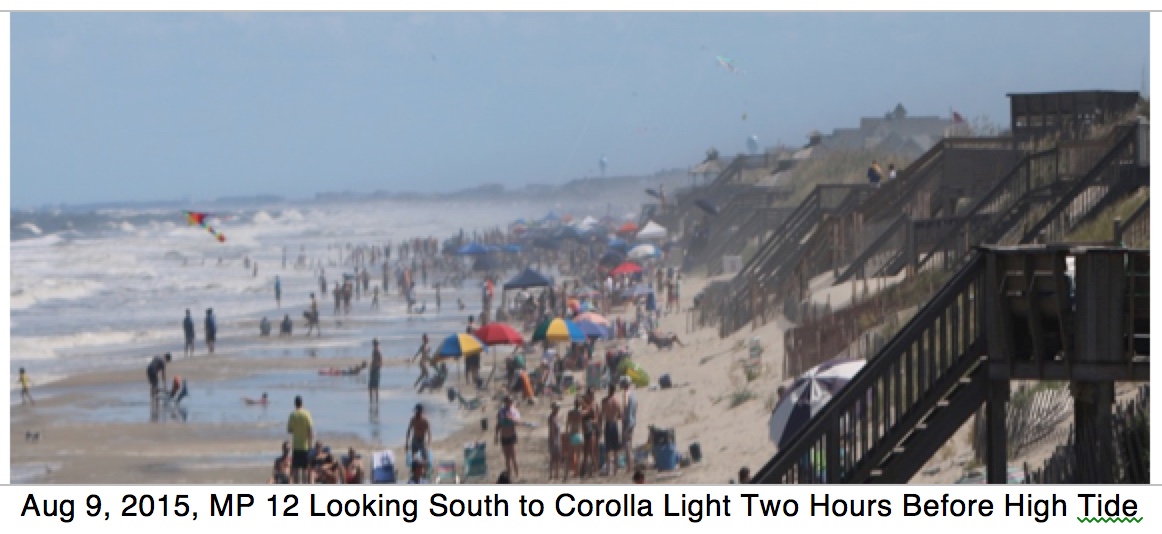
Lastly, the ocean continues its relentless push to the west. The 23+ miles of Currituck’s ocean beaches are the primary source of attraction and tax revenues to Currituck County, but they are steadily eroding away.  Are the mainland taxpayers prepared to absorb the tax burden of the loss of oceanfront homes over the next 20 to 30 years?  Will the taxpayers be comfortable with a crash effort started five to ten years from now to avert further property value collapse?  Or should the County begin now to prepare for the inevitable? There are demonstrated technology and political solutions to reverse the trend, but they are on a scale that, in Currituck, only the County can manage.   If you start now with a serious planning and savings effort you can send a positive message to investors that can help support property values, even in advance of beach restoration, given the security of knowledge that the County is prepared to manage the situation.

Corolla LIght beach crowding.jpeg
Comment

Ed Cornet

Ed Cornet, PhD, is a long time Currituck resident in Corolla. He has over six years of service as a member of the County's Economic Development Advisory Board and the Land Use Plan Steering Group. His business career was in high-tech industries and as a Partner of Booz Allen Hamilton. He has served on several corporate Boards. After retiring from business Ed was a Professor in the Kenan-Flagler Business School of UNC Chapel Hill where he established the STAR Program guiding MBA students to help NC businesses.

What Needs to Be Measured and Reported?

March 2018 - The Pine Island beach sand volume study was a good piece of engineering work, but its focus was more on basic coastal environmental science using the scientific community’s standards of cubic yards of sand in different regions.  This way of reporting the results is fine, but it missed the four most important metrics relevant to the health and economic well-being of a beach vacation community.  These should be part of the requirements for the Currituck County study. (March 2018)

1.    What is the width of the dry sand beach between the toe of the dune and the mean high-tide line, i.e. the width of the public dry beach? This gets directly to the issue of our relative attractiveness to beach vacationers and our beach’s tourist capacity, especially for renters of non-oceanfront properties.  It is also information easily extracted from the elevation data that is being collected in the traditional surveys.

2.    What is the average elevation of dry sand beach? This combined with beach width gives you a metric of how the beach will act to protect the frontal dune from storms by slowing the wave action before it impacts and undermines the dune face. Again information easily extracted from the elevation data normally collected to measure sand volumes.

3.    How close is the toe of the dune to the closest element of residential infrastructure? – pool, septic field, water wells (Corolla Light) or house?   This gets to the issue of how much time is left before significant property tax value loss occurs.  This can be estimated from the GIS database aerial surveys.

4.    How many cubic yards of sand would be required to raise the elevation of the dry sand beach and extend the beach width to be able to provide adequate width for vacationers and adequate protection of the beachfront property tax base?  (The estimated costs for cubic yard for current projects is well known.  I assume that your office is also aware of the time it takes to get permits and arrange contacting for the projects.)

Comment

Ed Cornet

Ed Cornet, PhD, is a long time Currituck resident in Corolla. He has over six years of service as a member of the County's Economic Development Advisory Board and the Land Use Plan Steering Group. His business career was in high-tech industries and as a Partner of Booz Allen Hamilton. He has served on several corporate Boards. After retiring from business Ed was a Professor in the Kenan-Flagler Business School of UNC Chapel Hill where he established the STAR Program guiding MBA students to help NC businesses.

Discussion Questions for 2018 Retreat

1. BEACH NOURISHMENT  1/14/2018

This topic has been discussed for years.  The evidence is real and there is no excuse for the County’s reluctance to act .  All facts stated here are from tax, LUP data sources or as referenced.

What’s the value of our beaches to our County?  The 2007 Tourism survey ranked our beaches as the #1 attraction by far.  The beaches generate the majority of the County’s tax revenues while requiring only a tiny fraction of the County’s budget.  COBX is only 9% of the land area, but it represents 55% of all property value and generates 65% of all tax revenues.  This keeps Currituck County’s tax rate low, leaving more money in the pockets of its citizens while creating additional investment resources for the County. This has been made possible by more than $3.0 Billion in private sector investment.  This investment generates about $30 M of total tax revenue for the County ever year.

Is this value in jeopardy?  Yes.  The USACOE continues to measure an erosion rate of 2 feet per year.  In 2003 Hurricane Isabel washed under some Corolla homes.  In 2005 the Currituck Chamber of Commerce first noted the weak rental market that persists to the present.  Property values dropped 40% from 2005 to 2013 and have not recovered. The beaches are narrower than ever with only a narrow strip of dry sand at high tide.  Meanwhile our closest competitors have invested to recover their wide beaches.  Mainland taxpayers are going to be in for another big tax increase in 2021 unless Currituck County management takes action.

Does beach nourishment work?  Yes.  These projects have been successful in over 400 other communities going back 50 years. Ref: National Beach Nourishment Database.  Nourishment is viewed as a cost of doing business, protecting a valuable asset. It does not stop erosion, but it re-establishes the wide beach loved by vacationers, protects oceanfront properties and enhances the beach experience for all beach goers.  Yes, it will likely have to be redone every 20 to 30 years to preserve the value, but its cost is only a small fraction of tax revenues that would otherwise be lost. 

Can we afford it?  Based on the recent Dare County projects it is estimated that restoring Corolla’s beaches would cost between $25 and $35 million.  This cost is a fraction of the more than $100 million in total Occupancy Tax collections since 2007 and less than one year of property tax, occupancy tax and sales tax contribution from Corolla. Yes, the County can afford it. With rental rates weak, property values down and oceanfront homes at risk you can't afford not to take action now.   To enable this to be done again 25 years from now the County should set aside and invest 10% of the Occupancy Tax proceeds each year going forward.  

Discussion of next steps– Who is going to take the lead?  What should be the timetable and end objectives? What is the best financing strategy to accomplish this quickly?  What is the best communication plan to let the private sector know that a future investment in COBX is safe?  

Comment

Ed Cornet

Ed Cornet, PhD, is a long time Currituck resident in Corolla. He has over six years of service as a member of the County's Economic Development Advisory Board and the Land Use Plan Steering Group. His business career was in high-tech industries and as a Partner of Booz Allen Hamilton. He has served on several corporate Boards. After retiring from business Ed was a Professor in the Kenan-Flagler Business School of UNC Chapel Hill where he established the STAR Program guiding MBA students to help NC businesses.

There Is a Lot at Stake - March 2018

An excellent two hour discussion was organized by the Pine Island POA Board yesterday in a session attended by Commissioners Hanig, Beaumont & White. 

Coastal Science & Engineering (CSE) is the professional engineering firm that has made the measurements of the Pine Island beach littoral profile for the POA.     Attached is their very complete primer on the subject.  On page 30 is a discussion of the strengths and weaknesses of hard surface solutions.   There is also some excellent information on the economic tradeoffs of cost of solutions versus the revenue value of the properties being protected.

The Pine Island POA paid CSE $37 thousand to have five miles of beach surveyed for sand elevations from the dune out a quarter mile into the ocean.  COBX has about 25 miles of ocean beach so for less than $200 thousand the same could be done by the County to begin to get a handle on the nature of the beach erosion problem.  For a beach vacation economy like ours the width of the dry beach in summer is key to renter satisfaction, so it is important to obtain even more precise information on this parameter.  Pine Island reported that Pine Island has lost 50 feet of width of their dry "recreational" beach since they began taking measurements.

As you all seemed to agree at your retreat this topic is worthy of a special meeting so that all of you may discuss the situation with the experts and begin to get a handle of what might need to be done, how much it might cost and the options to pay for solutions.  In the meantime, please consider putting a few hundred thousand of the Occupancy Tax (OT) money into a measurement program to give your smart County engineering team the data and the mandate to understand the magnitude of the problem and explore possible solutions.  It would also seem wise to begin to set aside at least a token amount, maybe a million per year from OT, into a seed fund for future action.

Below is a table of information from the County's 2016 Property Tax Records I compiled while working on the Land Use Plan. This indicates the property tax value that is in jeopardy as our beaches become less attractive for vacationer use due to continued narrowing of the dry sand "recreational" beach.

Table: $3 million in residential property value at risk due to beach erosion

Table: $3 million in residential property value at risk due to beach erosion

As the COBX property tax value declines mainland taxpayers pay more for the same services as happened in 2013.  You are not just protecting absentee owner property values, you are protecting mainland taxpayer from higher tax rates.

Thanks for your hard work helping your fellow citizens,

Ed Cornet

Comment

Ed Cornet

Ed Cornet, PhD, is a long time Currituck resident in Corolla. He has over six years of service as a member of the County's Economic Development Advisory Board and the Land Use Plan Steering Group. His business career was in high-tech industries and as a Partner of Booz Allen Hamilton. He has served on several corporate Boards. After retiring from business Ed was a Professor in the Kenan-Flagler Business School of UNC Chapel Hill where he established the STAR Program guiding MBA students to help NC businesses.

March 14, 2018 - Finally Planning to Do Something?

Dear Commissioners,


I understand that you will be having a work session on beach nourishment next Monday.  Unfortunately as I will be out of town, but I'd like to help clarify a few points in this email that some of you have raised in the past.  Any questions or issues with what I am saying please let me know.
0. This is a critical issue for the County. More than a million tourists come to Currituck beaches every year.  The beach area represents 55% of Currituck's property tax base and generates more than 65% of its tax revenues.  All beach property value is degraded as the beaches degrade.  The oceanfront properties alone are about 16% of the total County tax base.  As we found out in 2013 when beach property values degrade, taxes on the mainland go up.  The results in 2021 are on your watch.

1. The entire Beach Strand is open to the public in North Carolina even when the land is privately owned. (implying a public responsibility to assist in maintenance)  In our tourism area the important section is the Dry Sand Beach that is between the mean high tide line and the toe of the dune.  This is where beach goers put their blankets, chairs and tents.  The Recreational Beach measured in the Pine Island study also includes the Wet Sand Beach that is over-washed daily by tides, and the Surf Zone that is always underwater.  (During the Land Use Plan I put together a version of the graphic below and confirmed the legal access issues with Ike McRee)


All Currituck Beaches are Public Access Beaches

All Currituck Beaches are Public Access Beaches

2. Tidal variations as reported by NOAA for the Duck Station (below) indicate that over a month high tides reach two feet above mean sea level with low tides as low as 3 feet below mean sea level  (NAVD scale used by land surveyors)  Thus the dry sand beach for our tourists starts at an elevation of 2 feet above sea level (NAVD) and extends to the toe of the dune.  The width and elevation of the Dry Sand beach determines how many people our beach can accommodate in the summer, i.e. how crowded our beach seems.

The elevation is very important.  As was noted in the Daily Advance the beach elevation dropped three feet in the recent storm.  The lower the beach the more likely it is to be washed over at high tide when there are large waves.  At the current elevation normal high tides are washing all the way to the toe of the dune in many places.   Source of graphic below: NOAA

Tides NOAA.jpg

3.  The USACoE and NCDENR report long term erosion rates for the Currituck beaches as shown below. Fortunately Pine Island and the southern half of Corolla have erosion rates significantly less than the northern part of Corolla as shown below.   These erosion rates determine how quickly the ocean is approaching oceanfront property.  Corolla alone has 575 oceanfront parcels listed in the tax records with a total assessed value of $821 million.  Part of the beach surveying that should be done is how close real property is to the ocean today and then calculate how much time before the ocean is likely to encroach upon it.  I have estimated this for my subdivision using the GIS aerial photography taken in 2016. Ten percent of the homes have pools already breached last week with 50% of the pools threatened within 17 years at the current erosion rates.  The homes are set further back but the first one will fall prey to the ocean in 13 years and 50% within 37 years.  Harry Lee - the County's GIS guru - could get a benchmark for all oceanfront properties from the 2016 aerial surveys.   Source: CSE Study Report

COBX erosion rates.jpg


4. For future measurements the County should consider a more refined breakout of our Recreational Beach Zone to measure the amount of sand in the three components of the "Recreational Beach": dry sand, wet sand and outer surf zone: especially the width and elevation of the dry sand beach.  Source: The 2015 Pine Island Study Coastal Science and Engineering.

Beach volume analysis.jpg

Thanks for taking the time to read this far.   When I return in April I'd be glad to meet with you to answer any questions you may or address any issues you may see with my analysis.  With a clear set of factual information you will be better able to make the best decisions for the citizens of the County.


Regards,


Ed Cornet


Comment

Ed Cornet

Ed Cornet, PhD, is a long time Currituck resident in Corolla. He has over six years of service as a member of the County's Economic Development Advisory Board and the Land Use Plan Steering Group. His business career was in high-tech industries and as a Partner of Booz Allen Hamilton. He has served on several corporate Boards. After retiring from business Ed was a Professor in the Kenan-Flagler Business School of UNC Chapel Hill where he established the STAR Program guiding MBA students to help NC businesses.